University of Nebraska Omaha logo University of Nebraska Omaha
APPLY MY UNO DIRECTORY

Students Faculty Staff Community
University of Nebraska Omaha logo
International Programs Center for Afghanistan and Regional Studies
APPLY MY UNO DIRECTORY
Students Faculty Staff Community
  • About Us Backback to Main menu
    • Meet Our Team
    • The Center Today, History, and Mission
    • Products
    • International Programs at UNO
    • Contact Us
    • Support Us
  • Research Backback to Main menu
    • Afghanistan Transboundary Water Resources
    • Afghanistan Geography and Geology
    • Arthur Paul Collection
  • National Impacts Backback to Main menu
    • Afghan Refugee School Impact
    • Immersion Seminars
  • International Impacts Backback to Main menu
    • Young South Asian Leaders Initiative (YSALI)
    • Partnership 2020 (India)
    • Pakistan Teaching Excellence and Achievement (TEA)
    • Facilitating Connections Between Universities in Uzbekistan
    • Next Generation of Female Environmentalists (Pakistan)
    • Universities Linkages Project (Pakistan)
    • Women in University Administration (South Asia)
  • Afghanistan Projects Backback to Main menu
    • American University of Afghanistan Partnership
    • Kabul Polytechnic University (Workforce Development Partnership)
    • Kabul University-Balkh University Partnership for Communication Departments
    • Journalism Partnership with Kabul University
    • Teacher Training
  • News Backback to Main menu
    • Celebrating 50 Years
    • CASA Celebration Week
    • News and Updates
  • Alumni Stories Backback to Main menu
    • Pakistani Alumna Leading Sustainability in Local Community
    • Pakistani Teachers Return Home Making a Difference in Their Communities

DLM 5 Measuring Water

  1. UNO
  2. Center for Afghanistan and Regional Studies

Distance Learning Module 5 - Measuring Water

Water Volume Measures and Water Accounting

  • Volumes of water are measured in cubic meters (m3) or cubic kilometers (km3).

  • Flowing volumes of water are measured in cubic meters or cubic km per second (km3/sec).

  • One cubic km of water equals one billion cubic meters (bcm) – (1km3 = 1 BCM).

  • Traditional measures of water flow have been calculated by measuring the channel width (in m) and channel depth (in m), together with the water-flow velocity (in m/sec) to give the water-flow volume when multiplied together (m3/sec).

  • Many rivers have a known measured width and depth at certain places where the velocity can be measured periodically to obtain average river-water discharge (m3/sec).

  • In the 1950s – 1970s, the US Geological Survey (USGS) and the Afghanistan Geological Survey (AGS) built weirs or places on the river banks of Afghanistan to measure river discharge but most were destroyed after the Soviet invasion in 1979.

  • Since 2002, many new discharge stations have been re-erected all over Afghanistan to gather river water discharges again (Figure 5.1).


fig-5.1-stream-gauges.jpg

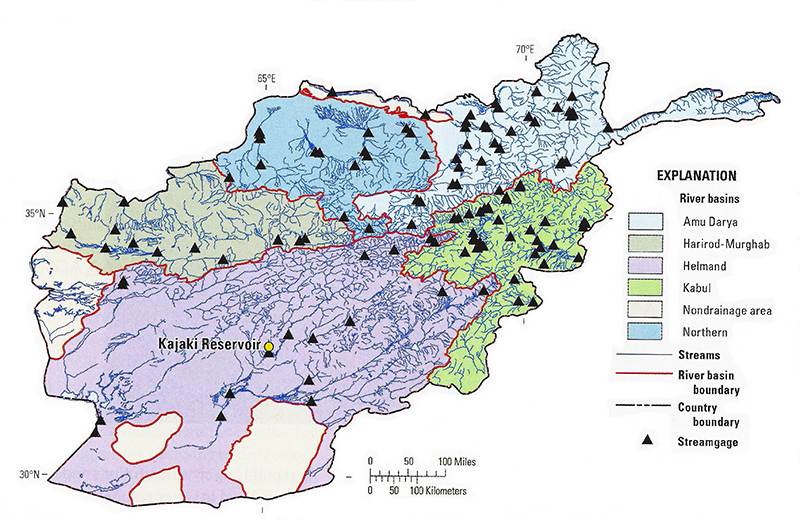
Figure 5.1. Map of the new stream gauges installed in Afghanistan by the Afghanistan Geological Survey (AGS) and the US Geological Survey. Why are there so few water gauges in the central and southeast parts of the country?


  • The collection of precipitation measuring stations also enables mapping the amount of rain in the country (Figure 5.2).


fig-5.2-mean-annual-precip.jpg
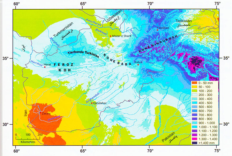
Figure 5.2. Average annual precipitation in Afghanistan and surrounding countries in mm. The map shows clearly that the average rainfall and snow fall are highest in the mountains of the northeast (dark blue and purple), and lowest in the Southwest of Afghanistan (orange-red).


  • Snowfall depths can be measured with radar beamed down from satellites in orbit and the snow depth or thickness converted to snow-water equivalent to predict most likely river discharges when the snow melts (Figure 5.3).


fig5.3
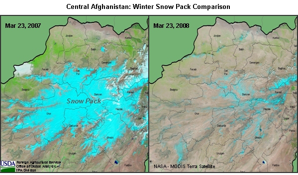
Figure 5.3. MODIS satellite image ‘pictures’ of the snowfall in Afghanistan on 23 March 2007 and 2008. What can you say about irrigation from these satellite pictures?


  • The US Geological Survey and the US Agency for International Development have been collecting such snowfall water data for Afghanistan for about 10 years. This can be obtained each year for free.

  • All this information helps the Government of Afghanistan to plan for irrigation agriculture each year.
  • The information also helps Afghans to negotiate successfully with neighboring countries over later water distributions.
  • Some satellite imagery can be obtained in near real time, that is, very soon after the image (picture) is taken by the satellite (Figures 5.4 and 5.5).


fig-5.4-precip-india-weihs.jpg

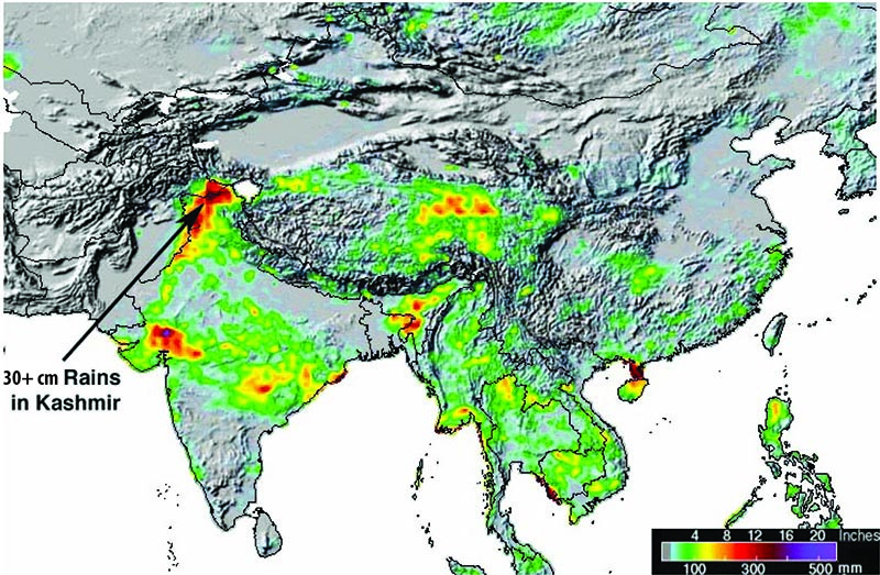
Figure 5.4. TRMM satellite measurements of rainfall can show where floods are occurring. This one showed that in September 2014 up to 356 mm of rain fell along the India – Pakistan border in Kashmir and caused huge floods. This rainfall was the result of the arrival of a strong monsoon low pressure over the region. The same thing happens in Afghanistan. Where is the most rainfall?


fig5.5

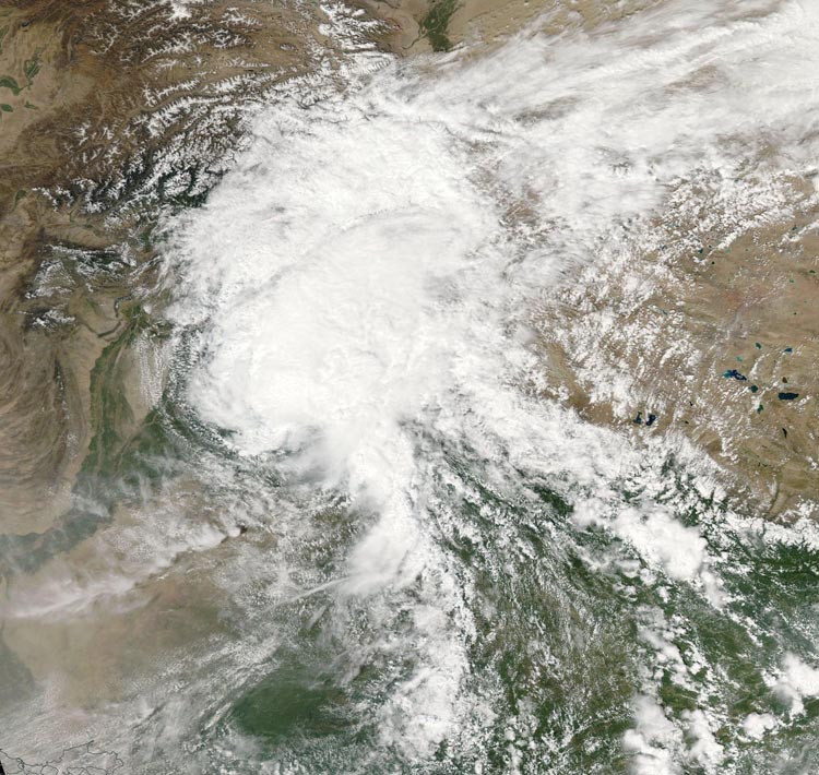
Figure 5.5. MODIS satellite picture of the monsoon low-pressure rainstorm of September 2014. Afghanistan is in the upper left-hand side of the picture, extending from the Spin Ghar Range and the Jalalabad valley, the Kabul Basin, up to the Amu Darya. The lakes of Tibet show on the right, and India is under the clouds in the lower right. Can you find the lower Indus River and the coast of Baluchistan?

  • Low pressure areas are places of storm and rain. The ITCZ is the average condition of storm and rain in summertime, which happens mostly in Pakistan and Southeastern Afghanistan (Figure 5.6).


fig-5.6.jpg
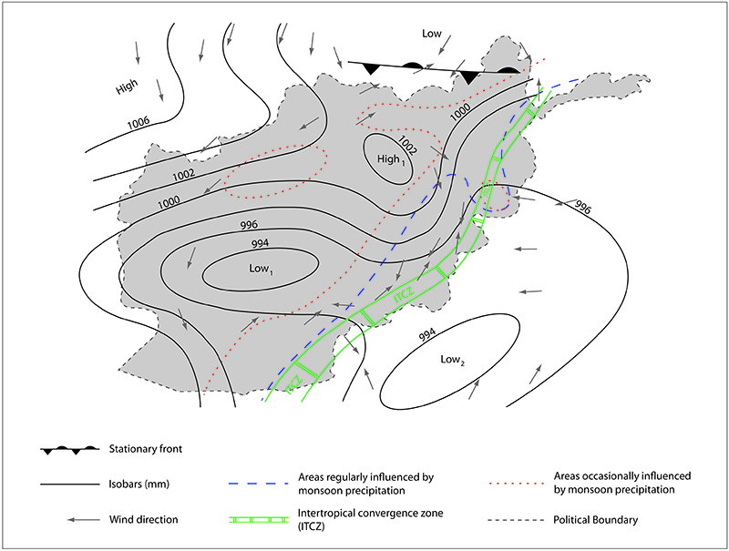
Figure 5.6. Weather map of Afghanistan in summer showing average location of monsoon low pressure (ITCZ – Intertropical Convergence Zone). When the monsoon rains come to Afghanistan, what two things happen?


  • Each year in Afghanistan, the condition of the vegetation and the agriculture is the result of available water (Figure 5.7).

fig5.7

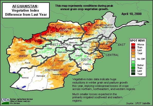
Figure 5.7. Map of Afghanistan in 2008 showing the vegetation index, which is made from satellite imagery. Where were the worst problems for agriculture, compared to 2007?


Distance Learning Module #5 Sample Questions (click here)

Contact Us

  • The Center for Afghanistan and Regional Studies
  • Phone: 402.554.2375
  • Email: unoafghanstudies@unomaha.edu

International Programs

Contact Us
  • International Programs
  • 241 Arts and Sciences Hall
  • 222 University Drive East
  • Omaha, NE 68182   map
  • 402.554.2293
  • world@unomaha.edu
Social media
Program Resources
  • Admissions
  • International Student Advising
  • International Studies Major
  • ILUNO Intensive English
  • International Professional Development (IPD)
  • Education Abroad
  • Center for Afghanistan and Regional Studies
Arts and Sciences Hall

Next Steps

  • Visit UNO
  • Request Information
  • Apply for Admission
  • The UNO Advantage
  • Our City (Omaha)

Just For You

  • Future Students
  • Current Students
  • Work at UNO
  • Faculty and Staff
  • A-Z List

Popular Services and Resources

  • my.unomaha.edu
  • Academic Calendar
  • Campus Buildings & Maps
  • Library
  • Pay Your Bill
  • Course Catalogs
  • Internships & Career Development
  • The Maverick Store
  • MavCARD Services
  • Military-Connected Resource Center
  • Speech Center
  • Writing Center
  • Human Resources
  • Center for Faculty Excellence

Affiliates

  • University of Nebraska System
  • NU Foundation
  • Buffett Early Childhood Institute
  • Daugherty Water for Food Institute
  • National Strategic Research Institute
  • Peter Kiewit Institute
  • Rural Prosperity Nebraska
  1. University Policies
  2. Privacy Statement
  3. Accessibility
  1. 402.554.2800

University of Nebraska Omaha
University of Nebraska Omaha, 6001 Dodge Street, Omaha, NE, 68182
  • ©  
  • Emergency Information Alert
  • MavsReport

Social Media


Omaha Skyline

Our Campus. Otherwise Known as Omaha.

The University of Nebraska does not discriminate based on race, color, ethnicity, national origin, sex, pregnancy, sexual orientation, gender identity, religion, disability, age, genetic information, veteran status, marital status, and/or political affiliation in its education programs or activities, including admissions and employment. The University prohibits any form of retaliation taken against anyone for reporting discrimination, harassment, or retaliation for otherwise engaging in protected activity. Read the full statement.